Trail On foot Schnals - Senales - Seerundweg - Photo

Tous les sentiers balisés d’Europe PRO

© OpenStreetMap contributors
Length
Length
3.1 km
Max alt
Max alt
1752 m
Uphill gradient
Uphill gradient
93 m
Km-Effort
Km-Effort  
4.6 km
Min alt
Min alt
1668 m
Downhill gradient
Downhill gradient
152 m
Boucle
Boucle
No
Signpost
Signpost
Creation date :
2022-02-15 05:41:28.461
Updated on :
2022-03-01 03:58:58.7

(0 Reviews)

On foot
On foot
1h02
Difficulty : Easy

Scan this QR Code to open this trail in the SityTrail application

FREE GPS app for hiking

Logo SityTrail SityTrail

IGN / Geographical institutes

Download SityTrail from the App Store Download SityTrail from Google Play

Logo SityTrail SityTrail World

The world is yours!

Download SityTrail from the App Store Download SityTrail from Google Play Download SityTrail on Huawei AppGallery

About

Trail On foot of 3.1 km to be discovered at Trentino-Alto Adige/Südtirol, South Tyrol, Schnals - Senales. This trail is proposed by SityTrail - itinéraires balisés pédestres.

Description

Symbol: blauer Fleck im geschwungenen schwarzem S in schwarzem Rahmen, darüber und darunter ein roter Streifen

Photos

Positioning

Country:
Italy
Region :
Trentino-Alto Adige/Südtirol
Department/Province :
South Tyrol
Municipality :
Schnals - Senales
Location:
Unknown
Start:(UTM)
638750 ; 5176862 (32T) N.

Trails nearby

Trail On foot Schnals - Senales - IT-7 - Photo
On foot
PRO

On foot

Easy
Schnals - Senales, Trentino-Alto Adige/Südtirol, South Tyrol, Italy
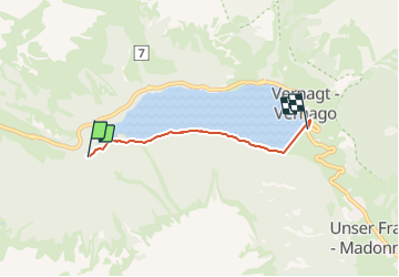
4.9 km | 7.1 km-effort
1h 37min
No
Trail On foot Schnals - Senales - 13 - Photo
On foot
PRO

On foot

Easy
Schnals - Senales, Trentino-Alto Adige/Südtirol, South Tyrol, Italy
7 km | 13.9 km-effort
3h 9min
No
Trail On foot Schnals - Senales - 5 - Photo
On foot
PRO

On foot

Easy
Schnals - Senales, Trentino-Alto Adige/Südtirol, South Tyrol, Italy
5.2 km | 8.7 km-effort
1h 58min
No


Close
My subscriptions